
Unpacking Rally
- wravenant
- Jan 14, 2022
- 13 min read
The sport we love is not one many people know about or understand.
Join in as I unpack rally racing in a series of posts leading up to the Karoo Roadbook Camp and the Dakar Rally to better understand our sport and why we love it so much.
Navigational rally racing is precision driving/riding while navigating instructions an organization (ORGA) has given to you in the form of a roadbook.
The goal is to complete the route defined in the instructions as fast as possible, while not incurring penalties.
Roadbook instructions are quite complex and you need experience to read and interpret the instruction and the terrain at speed. The roadbook gives you important information such as dangers (in a level from 1-3 in the form of a red exclamation mark), speed zones, waypoints, turns, etc...
You have to collect waypoints along the route, some are pre-determined and you know where they are (WPE) and some are hidden (WPM).
Speed is also important. While you can (and should) go as fast as you can (unless max speed is pre-determined by ORGA), in a special, there are often speedzones inside special stages (around villages, on national roads, etc...)
Missing waypoints and speeding will often result in high penalties. Basically its like a treasure hunt for grown ups...... on motorbikes, in race cars and race trucks, often times through vast open spaces in a desert.
The competitor who completes the stage in the fastest time AND with the least penalties (all waypoints collected and no speed zone infractions) is the stage winner. That's why often times the person that crosses the finish line first is not the day’s stage winner.
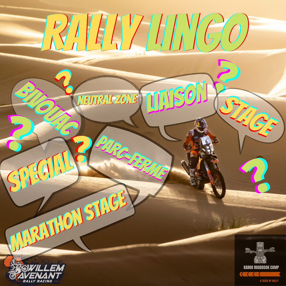
Some basic rally lingo and terms, part of the "unpacking rally" series, to get us all fired up for Dakar.
• RALLY-RAID : a rally that goes from point to point, held over a much longer distance than a conventional rally.
• PROLOGUE: a timed stage, usually short, that is run at the start of the rally and determines the start order.
• PARC FERMÉ : temporary holding of a race vehicle by the rally orga. Neither racers nor mechanics are allowed to touch vehicles once they are stored in the Parc-Fermé.
• BIVOUAC: this is where your days will start and end during the rally, where you will lay your head and where you will call home for the duration of the event.
It is the melting pot for the rally for competitors, mechanics, team staff, rally officials, medical staff and press representatives.
• STAGE: also known as an etape, is the route for a single day of a rally. Normally, a stage consists of liaison sections and the SS.
• SS: is short for Special Stage, also known as Selective Sector. This is the timed section of the race where you have to try and go as fast as possible. The race results are based on the sum total of the various SS times, minus penalties. The fastest time is the stage winner.
• LIAISON: the untimed section of the rally route. Since it is not always possible to start your timed race section at the bivouac, race vehicles must proceed from the bivouac site to the SS start point, complete the SS, then proceed from the SS end point to the next bivouac. Liaison sections are subject to time limits (with corresponding penalties), although these are not too demanding.
• NEUTRAL ZONE: this refers to sections between special stages in cases where a single stage is divided into more than one SS. Competitors are not timed in neutral zones, they travel under the same conditions as on liaisons, but they are not able to receive support from crews.
• MARATHON STAGE: where you are in charge of your own destiny, no mechanics or outside assistance is allowed during this stage lasting for two consecutive days. This is meant to level the playing field between large factory teams and privateers, in keeping with the old school rally philosophy.
Competitors are allowed to help each other, but you are only allowed to use what you can carry on your bike.
During a race it is common to see the top riders "taking it easy" looking after the bike and their tyres on a marathon stage, not wanting to risk their standings in the race with mechanical issues.
• ROADBOOK: a description of the following day’s route that is provided to the crews every evening by the organisers (more recently the roadbooks are only given out at the start of the special). It consists of a series of diagrams that display the main features and distances that characterise the route, traditionally on a paper scroll.
• SENTINEL: a safety system that is fitted to each vehicle. An alarm indicates the presence of any other competitor within 300 metres, and also indicates to the crew of an overtaking car that the other competitor is aware of their presence.
• TRIPMASTER: a precision distance indicator used for navigation.
• WAYPOINT (WP): a GPS zone defined by longitude and latitude coordinates. On the Dakar, there are five types of them: WPV (visible waypoint), WPM (hidden waypoint), WPE (eclipse waypoint), WPS (safety waypoint) and WPC (control waypoint). They indicate mandatory points on the route that the competitors have to pass through. The coordinates of their locations are not always revealed to competitors.
• TIME CARD: an official document where the competitors record all their passages through the time controls along the entire rally route. Loss of time card normally results in disqualification.
• TIME CONTROL: a checkpoint where competitors have to arrive within a certain time. They are located at the entry and exit of every service park, as well as at the beginning and end of each special stage.
• PASSAGE CONTROL: a different type of checkpoint located along the route, where competitors must have their time cards stamped by a marshal to prove that they have passed along the route.
• SZ : A speed control area as indicated in the road book, subject to a speed limit. This is marked by the letters ‘SZ’ in the road book to indicate the start of the zone and ‘FZ’ to indicate the end of it.
Decoding the rally bike cockpit, part of the "unpacking rally" series.
Riding/racing a rally bike, things can get busy very quickly. Understanding and knowing your navigation equipment intimately is very important:
Roadbook Holder
Houses the paper scroll with specific instructions at set distances/points on the route (tulips).
The most important part of navigation gear, it is normally an aluminum box with a clear screen, with an electric motor that scrolls the roadboook backwards or forwards. In a pich, the roadbook can be scrolled by hand with knobs on the side.
Trip Meter & Compass Heading
Two smaller instruments are usually mounted just above the roadbook. One serves as a trip meter to check your distance against the roadbook, and once serves as a compass heading repeater to make sure you are following the correct heading.
Back-Up Trip Meter
The more redundancy you have, the better your chance of finishing the stage, thus many professionals run a third back-up trip master in case of instrument malfunction. Often the back-up trip will run off the wheel distance (as opposed to running off the gps for distances) to increase redundancy.
GPS
The GPS is mainly used for validating waypoints during the stage. When you get close to a waypoint, the waypoint "opens'' and an arrow appears on the screen, guiding you to the waypoint. When you pass "through" the waypoint, it is validated and the arrow disappears.
There are different types of waypoints, which we will discuss later in the series.
Handlebar Switches
Navigation equipment is controlled by a switch on the handlebar. The roadbook is scrolled by a toggle switch. The trip meter distances are adjusted by buttons, while trip meter modes are selected by other buttons.
Safety Equipment
The safety equipment (Iritrack in Dakar's case), is normally mounted on the side of the tower. It allows real time tracking of the competitors by the orga. It also allows communication between rider and orga or vica versa as well as pass warning (from competitors coming up behind you) by the Sentinel.

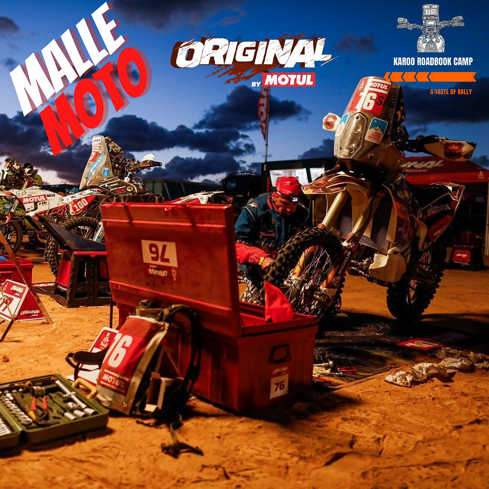
Malle Moto, part of the "unpacking rally" series
“Trunk Motorbike” in French, Malle Moto, stems from the golden days of the Dakar Rally, commonly mistaken for “Mal (crazy) okes on motorbikes in the desert”.

And crazy they are indeed, as they take on the toughest and biggest race i
n the world completely unassisted, in the spirit of what rally used to be before large factory teams entered the fray.
Renamed as “Original by Motul”, these guys are the toughest of the tough, revered by the factory teams at the Dakar Rally, they command a special kind of respect.
Each Malle Moto entrant is only allowed one malle or trunk. The trunk itself is a Pierre Henry 35 x 80 x 45 cm trunk. The Orga will transport the trunk between bivouacs. Normally the trunk contains all the spare parts, tools and gear you would need. Over and above the trunks, the Orga will also transport one set of wheels and tyres, a tent and one personal travel/clothes bag for each rider. Each year the Orga and the sponsor provides a few things to make life easier and more comfortable for the Malle Moto entrants.
Riders must prep, service, and fix their own bikes every day, without ANY outside assistance. Assistance between Malle Moto riders is allowed, though. Depending on what kind of day you had out on the stage, work on the bike can take a few hours, up to the entire night.
Once the bike is sorted, you still have the roadbook to mark for the next day, again something that can take many hours. You also have to eat and hydrate, and if you have time, shower.
Oh, and did I mention you have to pitch your own tent?
Coming off a bike after an entire day of riding, mentally and physically exhausted, and then having to do everything yourself leads to sleep deprivation and exhaustion. Many Malle Moto entrants run on 2-4 hours of sleep a night, depending on how their race is going.
Keep in mind this is not just for a day, but carries on for almost 2 weeks!!!
In 2020, 158 bikes started, and 96 bikes finished the race–a 60.6% finish rate. Of these, only 27 finishers were Malle Moto riders.
In 2121, only 20 riders finished the Malle Moto class, out of 63 bike finishers, where 108 bikes were entered.
The above statistics not only prove that the Malle Moto riders are MAL (crazy), but that they are giants among men, the toughest rally racers on earth….. RESPECT!
Photo credit - powersport.motul.com
Understanding the Roadbook, part of the "unpacking rally" series
The course is marked on a roll of paper called the roadbook (From 2023, electronic roadbooks will be mandatory at Dakar). The roadbook gives you all the relevant information, speed, distance, features, etc…, while you make your way through checkpoints and unmanned waypoints to get to the finish of the stage.
In theory, it sounds easy...right?
The blocks or instructions in the roadbook are called tulips (from the Tulip Rally/Tulpen rally of the 1950s where the directional diagrams in a roadbook were first used.)
Inside the blocks, there are symbols and abbreviations, called lexicons.
Understanding how to read and navigate a roadbook is the most important part of rally racing.
Reading this roadbook, at speed, interpreting unknown terrain, making decisions in split seconds, is one of the most exhilarating yet difficult things you will ever do…
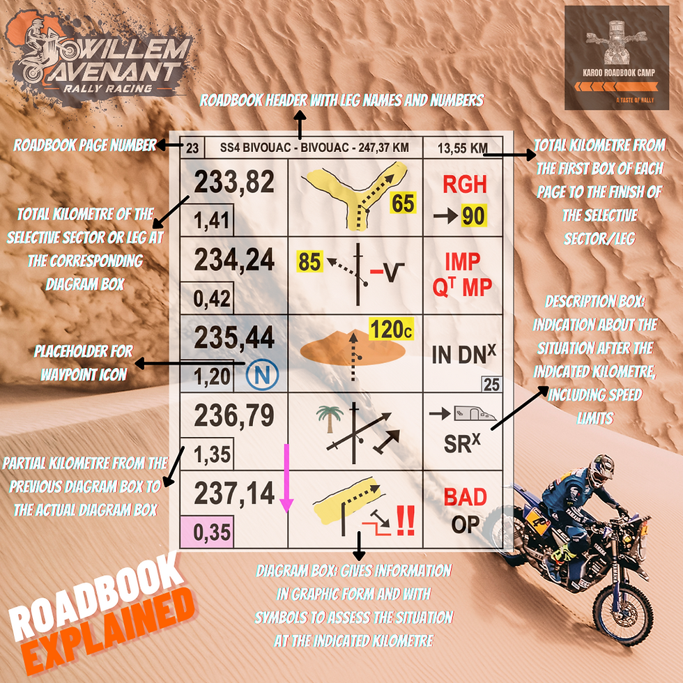
How reading a roadbook works, part of the "unpacking rally" series.
Roadbook excerpt from Redbull.com
The left-hand column of each entry shows distances, both absolute and in relation to the last point of reference. But since the riders rarely get to go in a perfectly straight line, they constantly have to recalibrate their odometers.
The central column has pictograms that depict the terrain and the route as well as the compass bearing. To understand these sections, the riders must memorise a special alphabet composed of more than 100 pictograms. The right-hand column has verbal prompts where applicable, but just so that things don’t seem too straightforward, they’re abbreviations of French words.

At kilometre 17.78, 530m since the last entry, look out for hidden checkpoint C [which would bring at least a 15-minute penalty if missed]. Caution! Potential danger area when you take a left to go offroad and into the dunes. [The text at right – HP DS DN – is an abbreviation of the French phrase hors piste dans dunes.] Compass bearing 268°.
At kilometre 18.60, 820m since the last entry, you come off Route L3 and take a gentle right into the dunes, where the road comes to an end. Compass bearing 180°, so due south.
Beware. At kilometre 18.94, 340m since the last entry, you have to hit a security checkpoint bang on. Maximum [three-exclamation-mark] alert!!! When you come out of the dunes [‘END DN’], a barely visible ditch is lying in wait on a bad track. [MVS is an abbreviation of the French word mauvais.] Once you’re beyond that, you carry on into a gentle right turn at a bearing of about 80°.
At kilometre 21.1, 2.16km since the previous entry, you go downhill through dunes interspersed with shrubs and a river that’s 300m wide. Then you have to come off road bearing right into a 50m-wide wadi [a dried-up riverbed, spelled oued in French], compass heading averaging 5°.
At kilometre 21.33, 230m since the last entry, turn right at the crest of the hill onto a highly visible marked track, alongside of which other tracks run in parallel. [ET P // is roadbook shorthand for et piste parallel – ”and parallel track” in French.]
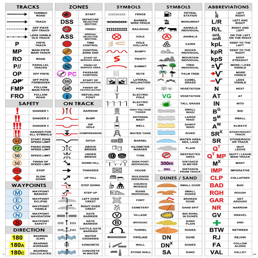
Lex·i·con - part of the "unpacking rally" series.

/ˈleksiˌkän,ˈleksiˌkən/
noun
the vocabulary of a person, language, or branch of knowledge. "the size of the English lexicon"
Learning and memorizing the rally lexicons help you to understand, read and interpret the roadbook more effectively.
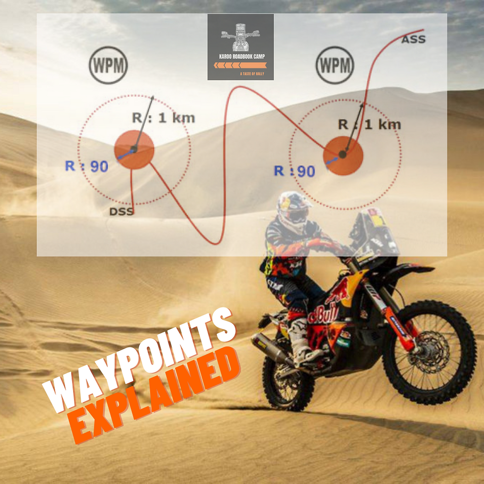
Waypoints explained, part of the "unpacking rally" series.
Excerpt from FIA 2020 CROSS-COUNTRY RALLY SPORTING REGULATIONS

Waypoints are points that competitors are required to pass through/validate.
“All waypoints are contained in the memory of the NAVGPS provided by the Organiser.
You must pass through all waypoints in chronological (ascending) order.
The penalty for the non-validation of a waypoint is stipulated by the regulations..
The total number of waypoints which may be missed during a leg is 40% of the total number of waypoints of the leg concerned.
If you have less than the required number of waypoints you are deemed to have retired from the leg and will be given the Leg Penalty for the leg concerned.
Should a crew wish to retire it may enter an emergency code, which will completely unlock the NAV-GPS and show all waypoints. The emergency code is “5555”.”
WPV (VISIBLE WAYPOINT) - Travelling towards a visible waypoint, all information is displayed on the screen of the NAV-GPS at any time when the WPV is selected. WPVs are usually used from the service park/bivouac to the SS start and from the SS finish to the service park/bivouac. In order to validate a WPV a competitor must pass within 90 metres of it.
WPE (ECLIPSE WAYPOINT)/WPN (NAVIGATION WAYPOINT) - A waypoint which becomes completely visible on the NAV-GPS once the previous one in the chronological order has been validated, whatever the distance between the previous one and the WPE/WPN may be. In order to validate a WPE/WPN a competitor must pass within 90 metres of it. The time penalties for missing a WPN are higher than for a missed WPE.
WPM (MASKED WAYPOINT) - The NAV-GPS directs the competitor towards this point only once he has come within a minimum 1 km radius of it. In order to validate a WPM a competitor must pass within 90 metres of it.
WPS (WAYPOINT SAFETY) - A waypoint used to ensure competitors’ safety. The NAV-GPS directs the competitor towards this point only once he has come within a minimum 800 m radius of it, or if a previous WPS has been validated if the distance is shorter. In order to validate a WPS a competitor must pass within 90 metres of it.
CAP headings explained, part of the "unpacking rally" series.
CAP headings could be the most fun, or the hardest part of a route.
It refers to degrees on a compass, north being 0 (or 360) and south 180.
HP / off piste / off track racing can only happen with the help of a given CAP heading due to the lack of defined paths or tracks. There is nothing quite like the feeling of heading into the desert on a cap heading into the unknown! It is surprisingly hard to keep a CAP heading in dunes or difficult terrain, and adds to the challenge of rally racing.
CAP headings can also be used for confirmations at complex junctions where there are several roads crossing each other.

Dangers/Cautions explained, part of the "unpacking rally" series.
Dangerous sections of the route are marked in the roadbook with exclamation marks (“!!!”). These can be holes, cliffs, big rocks, or any other hazard.
Usually, a single danger (“!”) is not a problem for motorcycles. But, a double (“!!”) could seriously injure you and a triple (“!!!”) danger could kill you.
Marking the big dangers in the roadbook is common practice and important for your safety.
Good and clear marking warns you ahead of time and gives you time to slow down.
It is now common practice to put a WPS (Waypoint Safety) at triple dangers.

Speed zones explained, part of the "unpacking rally" series.
Organisers must establish speed control zones when a Selective Section passes through a populated area and at other locations at their discretion.
The start of the speed control zone will be indicated in the Road Book by a box marked “SZ” and by a waypoint (WPS or WPE). 90 metres before this waypoint, competitors will be informed by their NAVGPS that they are approaching a speed control zone. 90 metres after this waypoint, the tolerance zone, within which no penalty applies, ends.
The end of the speed control zone will be indicated in the Road Book by a box marked ’FZ’ and by a waypoint (WPE). 90 metres before this waypoint the tolerance zone, within which no penalty applies, begins.
Speed regulations as per FIA 2020 CROSS-COUNTRY RALLY SPORTING REGULATIONS
OPERATION
A pulse signal is recorded in the NAV-GPS at least every 100 metres and the speed is displayed on the speed page of the NAV-GPS and recorded in its memory.
Waypoints associated with an SZ or FZ are validated only once the competitor is within a radius of 90 metres.
Within a speed control zone, organisers may specify a speed limit of 30, 40, 50 or 90 kph. The speed imposed will be permanently displayed on the NAV-GPS. If there is a divergence between the Road Book and the NAV-GPS, the information given by the NAV-GPS will prevail.
Organisers may establish not more than two successive speed zones with different speed limits. In the case of an acceleration, the higher speed limit will be enforced from 90 metres before the intermediate FZ/SZ waypoint (WPE).
In the case of deceleration, the lower speed limit will not be enforced until 90 metres after the intermediate FZ/DZ waypoint (WPE) see diagram below:
At the end of each leg the NAV-GPS may be inspected for excess speed. Any violations will be reported immediately to the Clerk of the Course. In the event of an infringement, the competitor will be penalised by the Clerk of the Course.
The penalties will be as follows:
- Between 1 and 5 kph:
10 seconds x the number of pulses
- Between 6 and 15 kph:
1 minute x the number of pulses + a fixed amount of €50
- Between 16 and 40 kph:
2 minutes x the number of pulses + a fixed amount of €100
- Over 40 kph:
- 1st pulse: 5 minutes + a fixed amount of €300
- 2nd pulse: 10 minutes + a fixed amount of €500
- 3rd pulse: 15 minutes + a fixed amount of €700

As part of our #unpackingrally series we will be having live discussions with some rally legends, and some of the movers and shakers in the sport.
Click on the top right hand corner of the video to see a complete list of all interviews.


Comments